An annoying problem has developed with the publication schedule of the Black Range Naturalist (BRN). I sometimes receive material which is excellent but the publication schedule of the BRN does not support timely publication of the material; drafts of the next two BRN’s may be close to final for instance. I may be working on a future issue of the BRN which is nine months out. Publishing something nine months after I receive it is not timely. So I (Bob Barnes) have decided to revisit the idea of publishing a blog on the Black Range (BR) website, to address this particular problem.
This blog (“Natural History Blog”) will be focused on getting material out there for people to see and react to, rather than on providing a researched piece. It apparently will not focus on catchy blog names.
Please provide your comments directly to me at rabarnes@blackrange.org.
@@@
Two New Videos - Rocks and Roads
Two new videos have been added to the video portfolios of the Black Range website.
The first is Rock Stars of the Black Range - Sublime Rock Formations - Volume 1. The Black Range is full of dramatic rock formations. This video is the first in (what may become) a video series which embraces their beauty without trying to explain their existence or give them names. This video has been added to the Follow the Contours page.

The second is a road video for Upper Berenda Creek & Pierce Road. This is the second road video to The Roads of the Black Range portfolio this year.
Aquarius remigis, North American Common Water Strider
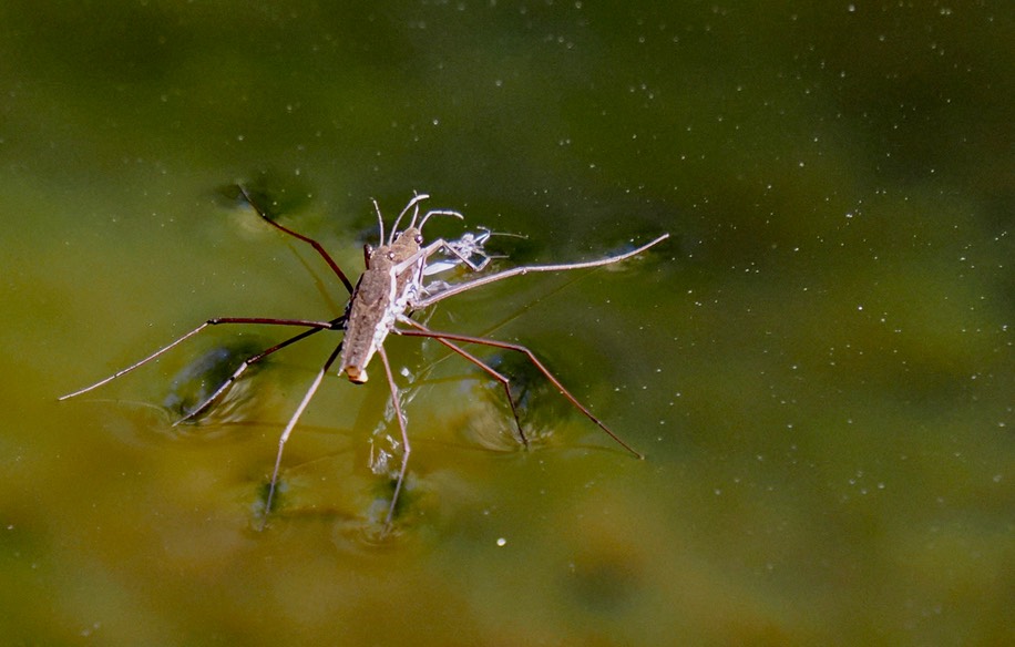
This entry is about a water strider, but only in part. Like much of the material on the Black Range website there is more going on than the title. But before we venture off into other topics, let us dispense with this small creature of just barely over a centimeter in length, a small creature that darts about without warning, a bug, a small bug, and thus difficult to identify in the best of conditions. Let’s get the boxing, a human prediliection to put things in boxes, out of the way. I believe the creature featured here should be placed in the Aquarius remigis (North American Common Water Strider) box. The folks at iNaturalist agree. The folks at bugGuide are working through the taxonomy, so far agreeing only that it is a water strider. Aquarius remigis is the water strider typically reported from this area. Aquarius remigis was first described by Say in 1832, although he placed it in the genus Gerris.
Boxed and set on the rack. I photographed these individuals on March 4 in Railroad Canyon, on the west slope of the Black Range.
Dolomedes gertschi, New Mexico Fishing Spider, preys on water striders. According to bugGuide its range is restricted to the Gila River drainage in Arizona and New Mexico. The waters of Railroad Canyon are in the Mimbres watershed, which drains into north central Mexico - but not at the surface. However, there are observations of this species of spider from Albuquerque and the Jemez Mountains listed at bugGuide and on iNaturalist from the Mimbres River. It is safe, I think, to state that fishing spiders found in this area will be of this species - by range. Why is this of any importance, given that I did not see this spider? BugGuide lists the following (unattributed) statement: "(Aquarius remigis) Faces a conflict when deciding which habitat refuge to use when responding to predators. Predation by sunfish (Lepomis) means these bugs need to retreat to the stream banks. But they must move away from those banks when avoiding fishing spiders (Dolomedes).” Now the stream in Railroad Canyon does not have any sunfish, but it is likely to have some fishing spiders. As a result, I suspect that I will be sitting near small pools in Railroad Canyon looking for water striders and fishing spiders - something I have not done before, but look forward to doing.

But a key point from the above may have been hidden from plain sight. The stream had water. It appears that the snow we had in the Black Range will pay dividends for a while, the flowers may bloom, the water striders may dart about, and a profusion of birds may be found this season!
Walks In The Black Range - 3rd Edition

A draft of the third edition of Walks In The Black Range has been posted to the Follow The Contours page on this website. We are accepting comments and additions through 01 June 2026. This is a community effort so please take some time and review the work. To access the draft follow this link, be aware that it is a large file.
The four volumes of the 2nd edition have been consolidated into one. This involved a fair amount of reformatting and editing. Trail descriptions have been updated and additions made. The 3rd edition:
- Describes 75 walks in the Black Range. In some cases multiple variations are described;
- Includes more than 700 photographs;
- Includes more than 130 maps;
- and includes numerous links to reference works and videos.
When the third edition is issued in final, previous editions will be removed from the website.
Using Yucca - The work of Bob Shipley

A couple of weekends ago, Bob Shipley stopped by the house to show us his new crutches. He had designed and made the forearm (aka elbow or Lofstrand) crutches from yucca, using other materials only as described below.
Most of us have walked the dry areas of the west and, thus, we know yucca. It may come in multiple species but the canes of all these plants, which are the flower stalks, are light in weight. We have picked them up, marveled at how something so light could be so resilient. We may even have crashed a cane against a rock to see how it splintered. On occasion we may have used one as a temporary walking stick. Bob had made his crutches from canes of this type. My first thought was that his effort might not be a good idea.
It is not that Bob shows up at the house anytime he has new crutches to show off. He is providing material for an article in the July 2026 issue of The Black Range Naturalist, on how he uses yucca in his art. He now lives in Albuquerque but lived in Kingston in the past and was making the rounds in the area - so why not show me his new crutches.
Bob is an engineer and a craftsman. Both skill sets are required for the art which he makes. He also knows how to describe his work in terms which people like me, who are neither engineers nor craftsmen, can understand. So one of the first things he did was tell me the crutches were made from yucca. My eyes immediately went to the bend in the crutches. I thought I caught a hint of a smile in the corners of his eyes.
He handed me the canes, “Yes Bob, they are very light." Perhaps I possessed the stuff of engineers after all, I could really tell they were light. And that they were truly made from yucca stalks. Yucca stalks which splinter rather too easily for me to think of them as crutches.

He took the crutches back, slipped his arms through the cuffs and put all of his weight on them. I wondered about my homeowners insurance. Then he handed them to me and insisted that I put my arms through the cuffs and put all my weight on them. I wondered about my medical insurance. I put all my weight on the crutches, no splintering. In fact, they were really comfortable, very light, they were like feathers at the end of my arms.
He took them back. I asked about the joinery where the hand grip joined the cane. The joint, pictured at the right, was fairly straightforward. This also gave me a chance to pay attention to the hand grip. The grip and the plastic/rubber “foot caps” are the only - except for the cuff, we will get to the cuff in a moment - parts of the crutches which are not yucca (except for some type of adhesive).
Noting how much I admired the joinery, he showed me another bit of work. This was the tour de force. That bit of yucca shaped like a squashed rectangle was what made the crutches “work”. This joint is necessary to create the 160° obtuse angle which mimics the natural bend of the elbow when it hangs straight. It was absolutely brilliant.

Crutches are typically made from lightweight aluminum, tubular steel, heavy-duty wood, or carbon fiber. These materials are used to minimize weight, maximize strength, and minimize cost. Crutches which break are not useful.
Breaking crutches brings us back to yucca crutches. Turns out that yucca is very strong in compression. When you place weight on something the load must be distributed in some fashion. Often the force of that weight is channeled to the ground (down the yucca shaft in this case). The ability of a material to withstand compression is called its compression strength (in materials). In compression the material is compacted, pushed together - as opposed to tension where the material is being pulled apart (think stretching a rubber band). When you place your weight on crutches you place compression on the shaft of the crutch - that is as far into engineering theory as we need to go for our purposes.
So my initial concern about the bend, the glance that caught Bob’s eye, was about to be addressed - with great glee, I might add.
The joint of the two pieces of yucca and the shape of the material used in the joint (a “rectangular wedge” created by Engineer Scientist Barry Spletzer specifically for this application) effectively align the force of compression with the structural character of the yucca. In other words, the downward force starts from the top of the crutch and is then refocused down the long part of the shaft - instead of being allowed to continue in a straight line. This ingenious craftsmanship and the attachment of the main load bearing element, the handle, on the straight part of the shaft address the limitations of yucca well and result in an optimal engineering design.
The cuffa are the other parts of the crutches which are not yucca. The cuffs were made of thin strips of oak soaked, rough formed over a hot pipe, and clamped around a custom-made form. Then the oak was laminated into a "sandwich" with a strip of chamois in the middle and bonded with Tightbond II adhesive. Oak will bend when properly treated and can be shaped, yucca will not.
And thus, a pair of forearm crutches evolved. A beautiful melding of form and function, made of sustainable materials. Art and science in one object.
And strong. Did I mention that Bob threw his crutches on the floor to demonstrate how strong they were? The man has flair.
Drone Crash

I have been working on the third edition of Walks in the Black Range. This is a big effort which will combine the four volumes of the 2nd Edition into one volume of just less than 300 pages, covering more than 70 walks in the Black Range with maps, photos, information on natural history, and a bit of human history on occasion. The third edition will also include many links to material on this website and to the videos included in our extensive Vimeo library. Over the last year I have been augmenting our video collection with the “Walks” linkage in mind. A set of drone videos has been added to the Mines of the Black Range showcase, for instance, bringing the total number of videos in that offering to 15. New additions include mines in the Hillsboro, Fluorite, and Lake Valley mining districts. In all cases, the videos provide an aerial perspective of the trails in the area.
A new page, Follow the Contours, has been added to the site as part of this overall effort. When the third edition of Walks is published it will be added to this page and the current “Walks” page will become history. Follow the Contours incorporates all of the ways of getting around in this country in one place. Although still under construction, you can view the page at the link above. Note that it has linkages to “road videos”, informational pages, and external resources.
At the top of the page there is a section of video links for a new series of “walk videos”. That section now includes several videos of walks up side canyons on the north side of the middle box of the Percha. Included in this section are some 360° video clips which allow you to use your cursor to explore the video in ways you may not have done in the past. And, lastly, and to the point of this blog entry, there will be aerial videos of the canyon walks. In addition to being time-consuming and technically demanding it can be strenuous (oops!- invigorating) and involve a fair amount of stumbling around. Just to say that things don’t always go as planned. Sometimes you just have to pick yourself up out of the sand and keep on trucking. It is in that spirit that the following embedded video is offered.
But most of all, remember the foothills of the Black Range are dramatic and beautiful. As seen in the framegrab from the current effort, shown above.
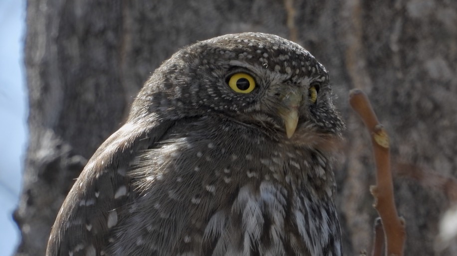
More Owl and Side Canyon Videos
Yesterday we posted video of Mountain Pygmy-Owl which we recorded in the yard earlier in the day. See the January 8, 2026 post for earlier photos and information. The video has been included in The Birds of New Mexico video portfolio. This video is embedded below, followed by photographs from the session.

We also posted video of a walk up one of the Percha Creek side canyons, the middle route on the map below, in support of the 3rd Edition of Walks in the Black Range, which is in preparation. This video is available in the Follow The Contours video gallery and is embedded below.

Percha Creek Side Canyon (“A”)
Yesterday we were recording walks in two of the side canyons of Percha Creek in support of the forthcoming third edition of Walks in The Black Range.
The video editing on the first walk is now complete and may be viewed at this link. The walk is 2.1 miles (one-way) and has a moderate elevation change of about 400’. It is the right hand walk on the map below. (See the “Follow The Contours” video portfolio for other walk videos.)

There is a “micro-slot” on this walk, a short 360 video clip of the slot is embedded below. Play the video and move your cursor around to see the slot from many different angles.
Cave Creek
For all intents and purposes, Cave Creek is at the end of the road when you take a drive on FR-157 (aka North Percha Road and in some sources 4088N). On the 30th I went with others to Escondida Spring. Starting at NM-152 we turned north on FR-157, drove through private land to the USDA Forest Service managed land, continued to North Percha where we crossed some in-holdings, crossed the creek, journeyed past Bald Hill, and then into Cave Creek Canyon. Escondida Spring is as far as you can go on this road without entering State Trust lands. All of the streams and stream crossings we encountered were dry (ignoring a short section in Carbonate Creek just upstream from the ‘waterfall’). The map below shows a portion of the route (the area near Bald Hill is at the top of the map).

I recorded a video of the section of the route shown in the map below. The video may be viewed at this link. It has been added to “The Roads of the Black Range” video gallery and it is embedded below.

The raw footage for this video was recorded in a 360 degree format. A short clip of 360 degree video may be viewed at this clip. This clip is embedded below.
Frankly, I am not sure where Escondida Spring is, the Lat/Long (decimal) coordinates are 33.01257,-107.69337, but I could not find a spring - unless it is what was spotted on a hillside in the area (photos below).

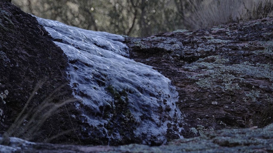
I especially liked photographing this bit of H2O. Temperatures have been below freezing at nights for quite some time and the water has frozen to ice. It looks like a slow shutter speed image of a waterfall to me, that glossing over of detail that some like, only it is the water which is slow - well, because it is ice.
If anyone can educate me about Escondida Spring I would appreciate the information. Thanks.
-Bob Barnes, Hillsboro
A SpaceX Launch

On January 2 of this year John West, who lives in the Black Range, took the photograph shown above. It immediately created a great deal of consternation. It was not taken in the Black Range, in fact quite far away - west of Phoenix. The vegetation was not the Black Range type - but Sonoran. The focal point was not natural history, instead a satellite launch.
But it is the best photograph I have seen in a long time. And I dare say, I see a lot of photographs. And, of course, we are talking subjectivity here, major subjectivity, and lest I drift into the interpretive side of art - probably the type of discourse I hated most as an undergrad - let me just say that I like it and leave it at that.
Why did it make it onto The Natural History Blog? ‘cause.
Mountain Pygmy Owl
As an update to the article in the January 2026 issue of this journal, about the species which visited a bird bath during 2025, we add this observation. A Mountain Pygmy Owl, Glaucidium gnoma, visited a bird bath in Hillsboro on January 4 of this year, bringing the “yard list” for that yard to 178. It was also seen in the yard the day before. This species is diurnal.


The taxonomic designation of the population found here is disputed. The IOU (International Ornithologists’ Union) considers this population a full species (see range map below by Simon Pierre Barrette via Wikipedia, it is shown here under a Creative Commons Attribution-Share Alike 4.0 International license). In this treatment, the population found here is the Mountain Pygmy Owl, Glaucidium gnoma. The Northern Pygmy Owl, Glaucidium californicum, range is also shown below under the same license, according to the IOU.

Various sources (The American Ornithological Society [AOS] and the Cornell Lab [All About Birds], for instance) do not recognize the Mountain Pygmy Owl as a full species. Instead, they consider this population to be a subspecies of the Northern Pygmy Owl, along with various other Pygmy Owls in Mexico and Central America.
At this level, the taxonomic determination of this population is pretty straight forward. It is in dispute. Lumpers consider it part of the Northern Pygmy Owl complex, splitters consider it a separate species (they also consider other populations in Mexico and Central America to be full species [e.g., the Guatemalan Pygmy Owl, Glaucidium cobanense]).
But let us not leave well enough alone. The IOU and AOS use some of the same English common and Latin binomials to describe the various (grouped or split) species populations. It can be very confusing.
For our part, we throw our weight (something less than that of a piece of down) behind the IOU based on our personal observations of the various species.